Korea Travel Essentials #1: Download Naver Map and Switch It to English

Part 1 of Korea Travel Essentials — five things to set up before you arrive in Korea.
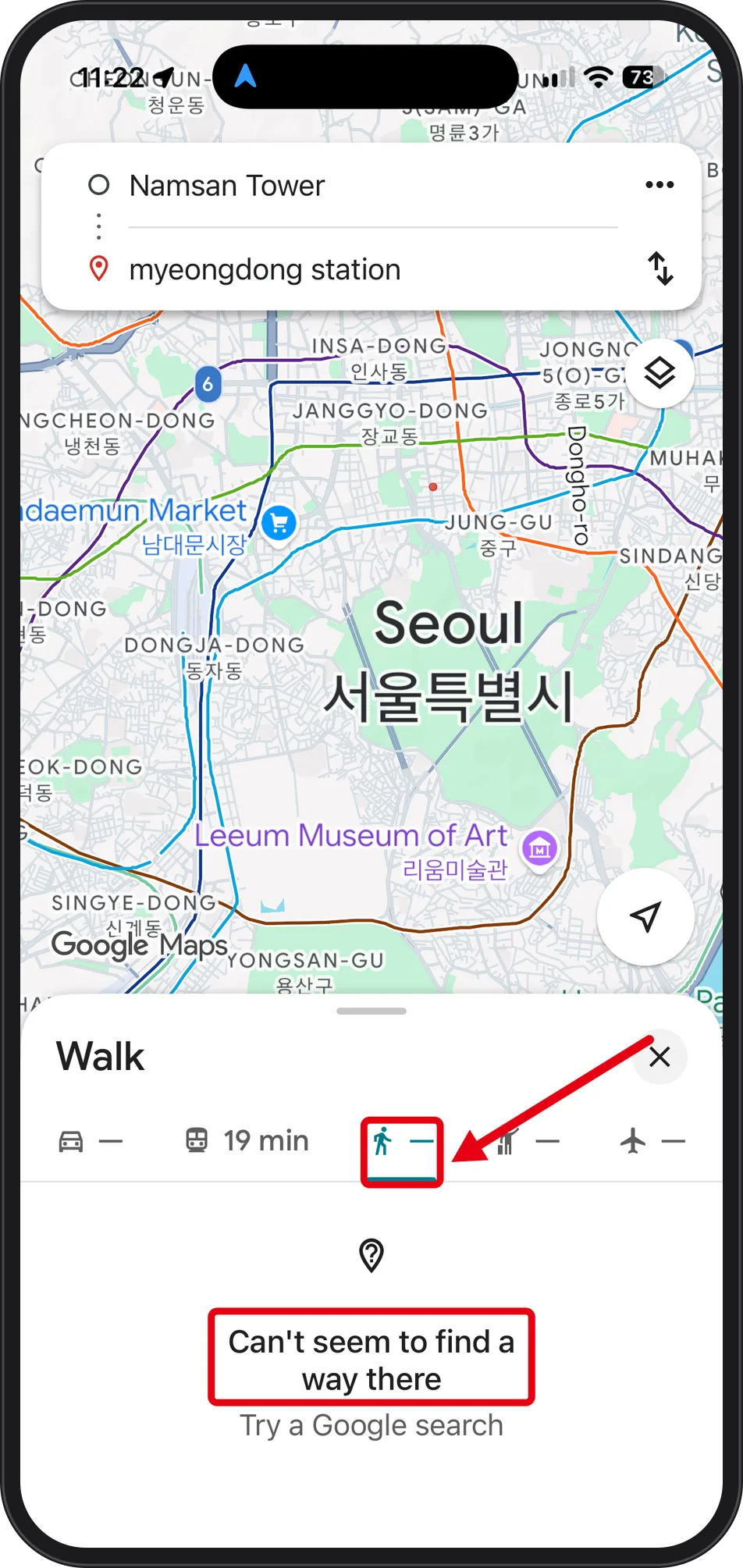
In our test in Seoul, Google Maps returned no walking route at all, while its transit search worked normally. For walking, NAVER Map with its app language set to English gave a full route with options. The screens below were captured in Seoul on 2026-10-07 between 11:15 and 11:23 PM on an iPhone.
| Task | App | What the screen shows |
|---|---|---|
| Walking, Namsan Tower → myeongdong station | Google Maps | "Can't seem to find a way there" |
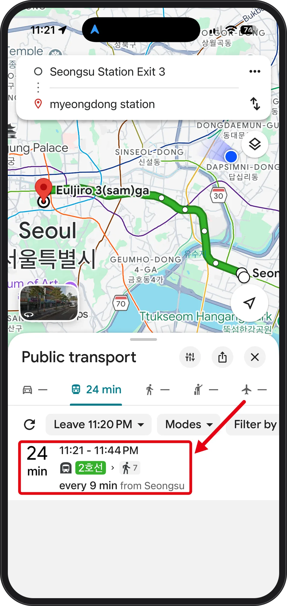
| Transit, Seongsu Station Exit 3 → myeongdong station | Google Maps | 24 min, 11:21–11:44 PM, Line 2 |
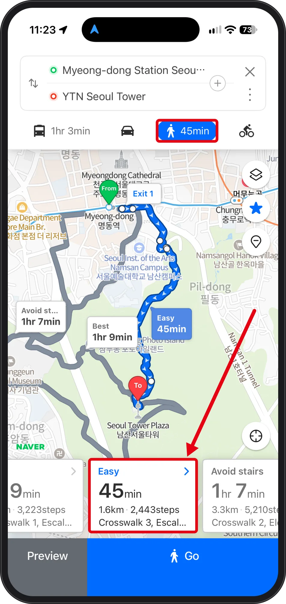
| Walking, Myeong-dong Station → YTN Seoul Tower | NAVER Map | Easy 45min · 1.6km · 2,443 steps |
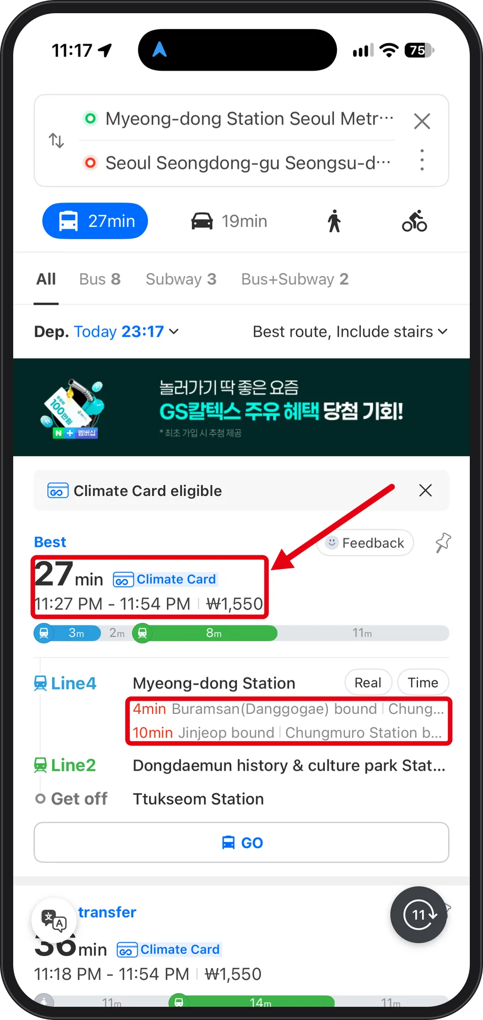
| Transit, Myeong-dong Station → Seongsu-dong | NAVER Map | 27min, ₩1,550, Line4 → Line2 |
Step 1. Why add a local map app: what our walking search showed
 Source: Google Maps app screen (captured Oct 7, 2026)
With Namsan Tower as origin and myeongdong station as destination, the Walk tab returns "Can't seem to find a way there / Try a Google search". On the same screen the driving tab shows only a dash with no time, while transit shows 19 min.
 Source: Google Maps app screen (captured Oct 7, 2026)
The second pair, Seongsu Station Exit 3 → myeongdong station, returns a full transit result: 24 min, 11:21–11:44 PM, Line 2 (2호선) plus 7 minutes of walking, every 9 min from Seongsu. So nothing is broken on the device — do not reinstall or reset. Only point-to-point walking needs another app. Why Google cannot route walking here is not visible on these screens, so this guide makes no claim about it.
Step 2. Set NAVER Map to English before you need it
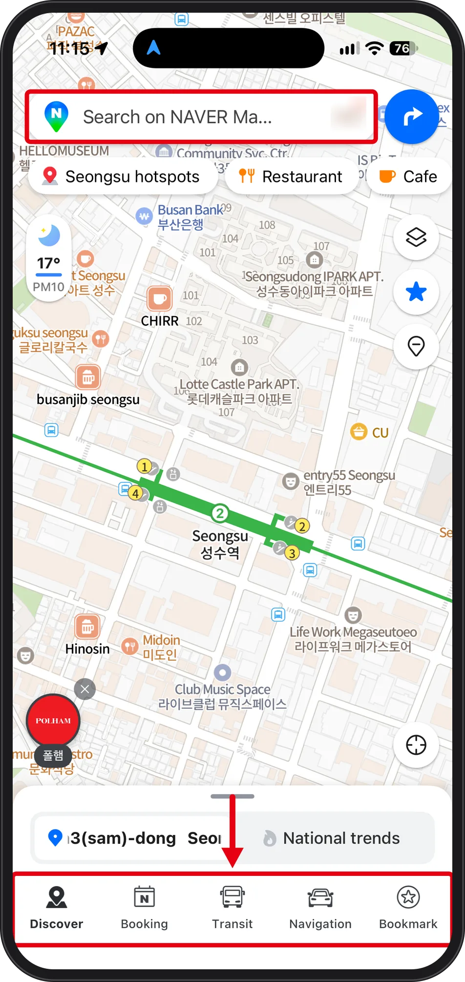
Open iPhone Settings → NAVER Map → Language. This row only appears when the app offers more than one language. If your phone is already set to English, check whether NAVER Map opens in English before changing anything.
 Source: NAVER Map app screen (captured Oct 7, 2026)
After the switch, the search bar at the top reads "Search on NAVER Map" and the bottom tabs read Discover · Booking · Transit · Navigation · Bookmark. Map labels stay bilingual — English above Korean, for example Seongsu 성수역 — which lets you match the Korean text on street and station signage.
Step 3. Type the station name with no spaces, then tap Get Directions
 Source: NAVER Map app screen (captured Oct 7, 2026)
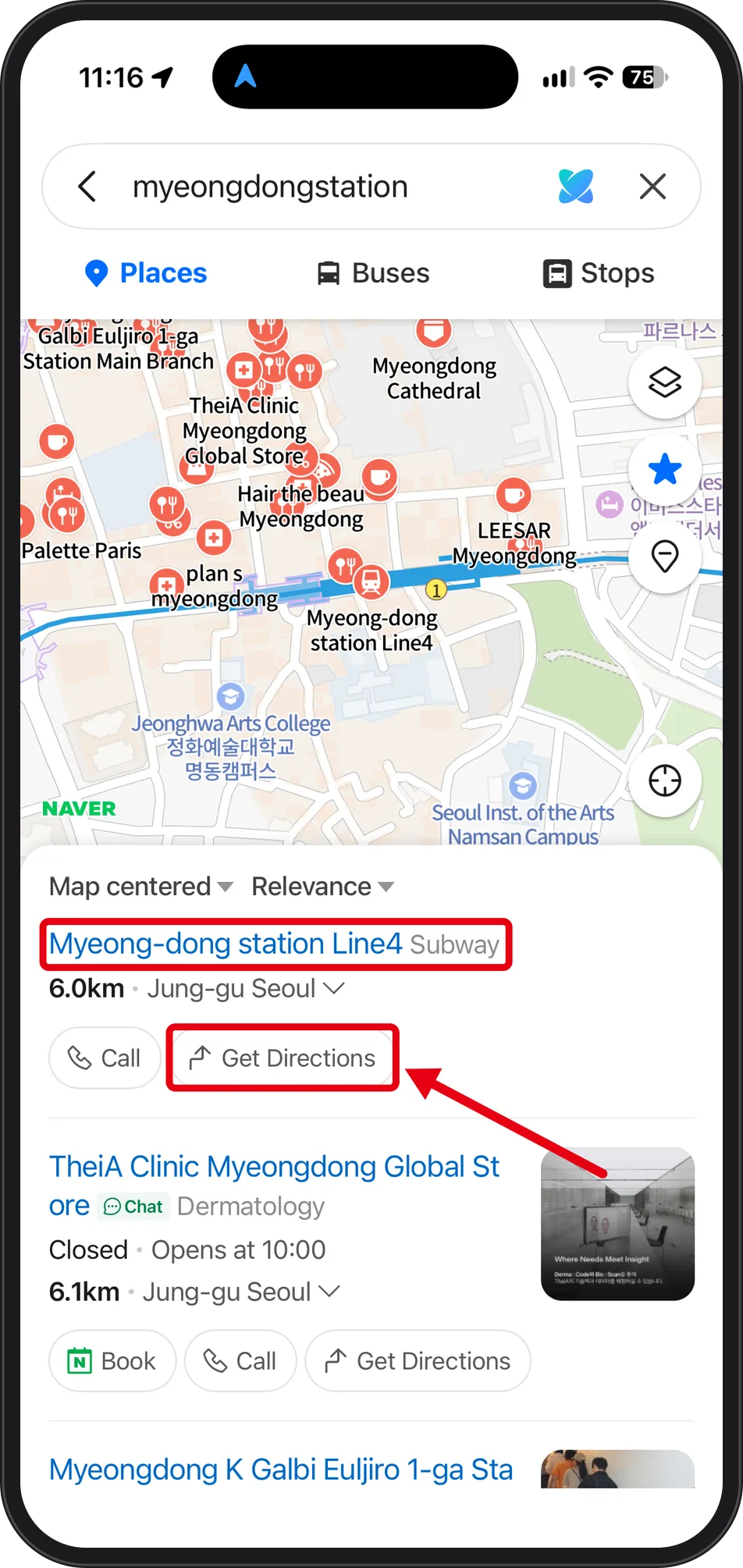
The query was entered as "myeongdongstation" with no space and the station still came back. Result tabs run across the top: Places · Buses · Stops. The top card reads "Myeong-dong station Line4 Subway" with 6.0km and Jung-gu Seoul beneath it.
Tap Get Directions on the result card itself instead of returning to the map. Look-alike results such as Myeongdong Cathedral, clinics and stores sit above and below, so read the "Line4 Subway" line before tapping.
Step 4. Read the walking card: Easy, Best, Avoid stairs
 Source: NAVER Map app screen (captured Oct 7, 2026)
For Myeong-dong Station → YTN Seoul Tower, the walking tab headlines 45min. One card holds three options: Easy 45min · 1.6km · 2,443 steps · Crosswalk 3; Best 1hr 9min; Avoid stairs 1hr 7min · 3.3km · 5,210 steps.
Avoid stairs is more than twice the distance of Easy, and the card states that cost in both kilometres and steps — useful if you are pushing a stroller or wheelchair or dragging a large suitcase. The map marks the start as "From Exit 1", so you know which subway exit to surface from. Transit for the same pair reads 1hr 3min on the same screen, so walking is the faster option here. At the bottom sit Preview and Go.
Step 5. Switch to Transit when the walk is too long
 Source: NAVER Map app screen (captured Oct 7, 2026)
Myeong-dong Station → Seoul Seongdong-gu Seongsu-dong shows 27min, 11:27 PM–11:54 PM, ₩1,550, with departure set as "Dep. Today 23:17". The route is Line4 from Myeong-dong Station → Line2 at Dongdaemun history & culture park Station → get off at Ttukseom Station.
A Real Time block lists 4min Buramsan(Danggogae) bound and 10min Jinjeop bound. The best route also carries a "Climate Card eligible" marker. Filter tabs read All · Bus 8 · Subway 3 · Bus+Subway 2, and driving on the same screen shows 19min. The fare and timings belong to that route on that night only.
What these screens do not answer
The cause of Google Maps' missing walking routes was not visible in these captures, so no policy or legal explanation is given. Kakao Map was not captured, so no comparison is offered here.
Also not captured: the in-guidance screen after tapping Go — remaining distance, next-turn display and off-route behaviour — and how the location marker behaves inside underground malls. Every time shown, and the ₩1,550 fare, are the values for those specific origin-destination pairs on 2026-10-07 between 11:15 and 11:23 PM.
One practical note from the screens: read the exit number on the route map ("Exit 1" beside the From pin) before you start walking — it tells you which subway exit to come up from.
Back to the series: Korea Travel Essentials: 5 Things to Set Up Before You Arrive


